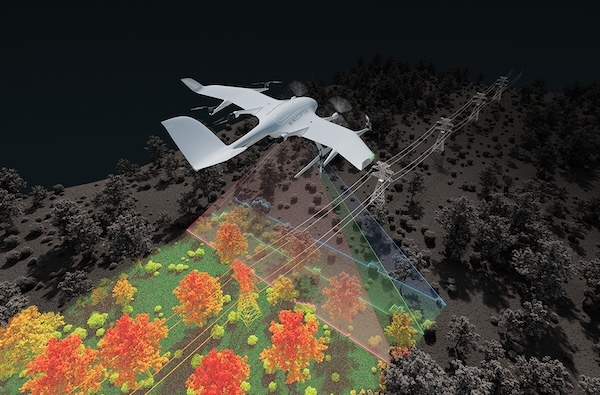
Wingcopter announced that it will expand its offering beyond cargo drones to include the sale of long-range BVLOS LiDAR surveying solutions. For this, the Wingcopter 198, company’s flagship product, will be equipped with superior laser scanning and camera systems, enabling the efficient and rapid collection of high-quality data. The aim is to give customers the opportunity to survey up to 37 miles (60 km) of linear infrastructure in one mission, carrying a 10 lbs (4.5 kg) sensor system. Potential use cases include the inspection of power lines, pipelines, railways and roads, as well as the mapping of terrain and vegetation that is difficult to access.
The announcement was made at GEO WEEK in Denver, Colorado, where Wingcopter is currently showcasing its new application. The planned system allows to collect up to 570 pts/m2with a sensor accuracy of 10 mm and a precision of 5 mm, significantly outperforming existing solutions in the market. Using a Wingcopter with a high-end LiDAR, customers can scan up to 2,560 acres (10.3 square kilometers) in a single 42-minute BVLOS mission.
Ansgar Kadura, Co-Founder and Chief Strategy Officer at Wingcopter, commented: “After years of developing and relentless testing, we have frozen the Wingcopter 198 in the configuration that is currently undergoing FAA type certification in the United States. The drone has unique payload and range characteristics, and with a proven product lifetime of more than 1,000 flight hours, it is one of the most reliable long-range eVTOL UAS on the market. Based on this configuration, we are developing a solution to address the field of high-quality LiDAR surveying and integrating the best commercially available sensor systems. I look forward to discussing with surveyors and learning about their vision for an ideal BVLOS LiDAR surveying drone.”
Strong interest comes from Brazil, where Synerjet, Wingcopter’s authorized local partner, plans to deploy fleets of Wingcopter 198 drones in the surveying market. Augustinho Simoes, Synerjet’s Director of Drone Operations and Development, stated: “Together with Wingcopter, we are developing custom applications, adding more functionality to the aircraft and meeting requirements from other industries, such as asset inspections, vegetation monitoring and mapping. The first version will be equipped with a high-end LiDAR sensor that offers a wide 100-degree field of view and an extremely high pulse repetition rate of up to 2.4 MHz. The measuring beam is emitted consecutively in three different directions: it alternates from strictly nadir to +10 degrees forward, and to -10 degrees backward. This allows data acquisition with unparalleled completeness in data capture, especially in challenging environments with vertical surfaces, narrow canyons, transmission lines, railways, highways, forest plantations and many other applications.”
Few infrastructure projects have the potential to reshape an island's future quite like the ongoing transformation of Nevis Airport. To gain deeper insight into this ambitious development and the...
A professional training device such as the new PC-12 PRO simulator is built on flight data supplied and validated by Pilatus. Drawing on actual flight-test and performance data, it accurately reproduc...
The U.S. Federal Aviation Administration has certified the Boeing 737-10, the newest and largest member of the 737 MAX family, paving the way for Boeing [NYSE: BA] to begin customer deliveri...
Air Baltic Corporation AS , Latvia’s national airline and the leading carrier in the Baltic States, announced that airBaltic and its subsidiaries participating in the voluntary Ch...