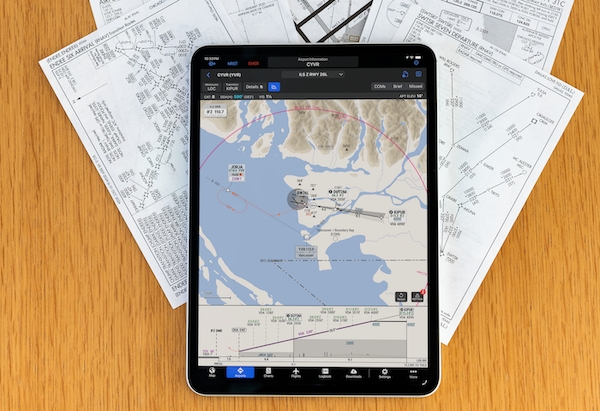
Garmin announced the expansion of SmartCharts for Garmin Pilot Premium users in Canada and Mexico on both web and Apple mobile platforms. The dynamic aviation charting solution provides pilots a simplified and intuitive experience by producing clear and relevant data to depict a chart tailored for their specific flight operation.Originally announced in May 2025, SmartCharts is designed to help optimize pilot workflow by providing only relevant data and reducing workload. Users can make selections – like aircraft type, arrival/departure/approach transition fix, runway, and more – to simplify the chart down to the information that they need to see to successfully brief and fly that procedure.
Starting with standard terminal arrivals (STARs) and standard instrument departures (SIDs), the user selects their aircraft type, the route transition they are flying, and the runway of intended use. This reduces depicted information to only show the routing, fixes, and crossing restrictions pertinent to their expected procedure. Quick Access buttons also reveal pertinent procedure information like briefing information, communications frequencies, graphical missed approach icons, and more so pilots can easily find and decipher information based on the phase of the procedure they are on.
In addition to all the previously announced SmartCharts features, pilots in Canada and Mexico can now take advantage of the Continuous Descent Final Approach (CDFA) path shown on the vertical profile view. CDFA allows pilots to descend continuously on a constant path during a non-precision approach, providing a more stable approach and reducing pilot workload. Additionally, cold weather adjustments are available for Canadian and U.S. airports, allowing pilots to operate to cold temperature restricted airports and see the calculations and cold weather corrections within SmartCharts.
Additional SmartCharts improvements in this release include a missed approach climb gradient table being displayed on approach charts and applicable climb gradient values being shown on departure procedure charts.
SmartCharts are included with a Garmin Pilot Premium subscription for pilots operating in the United States, Canada or Latin America regions. For pilots who fly across multiple regions, a Worldwide subscription option is also available. These updates are available now on Garmin Pilot Web. Garmin Pilot mobile users can update to version 26.8 via the App Store.
flyadeal, the fast-growing low-cost carrier of Saudia Group and one of the GCC's largest budget airlines, has expanded its presence in India with the launch of non-stop flights between Riyadh and...
TRU Simulation + Training Inc. will showcase its Veris Virtual Reality Flight Training Device (FTD) for the Cessna Skyhawk at NBAA-BACE 2026, marking the simulator's first appearance at the indust...
FlyJets, the charter aviation marketplace and flight-sharing exchange, has officially launched JetGPT™, its AI-powered automated flight-finding agent, coinciding with a growing portfolio of flig...
Sky Travel and parent company Cove Capital Investments, LLC, have unveiled plans to bring nearly 20 business aircraft to market during Q4 2026, reinforcing their commitment to meeting growing demand f...